FROPA!
- Neil Lareau
- Jan 25, 2018
- 1 min read
Yesterdays storm impacting the bay area illustrates some of the complexities of frontal systems. Here's a quick radar overview of the frontal system as it moved onshore:
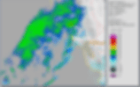
Note the leading surge of intense precipitation along a narrow, segmented band. This is called a "Narrow Cold Frontal Rain Band" and it demarcates the leading edge of cold air advancing from the NW to SE and undercutting the warm, moist southwesterly flow aloft. The deeper cold air lags significantly behind the leading edge, and is associated with the broader, more stratiform region of precipitation (i.e. a "wide cold frontal rain band") Both these features are quire clear in the radar wind profilers at Fort Ord and Bodega Bay.


This sort of frontal dynamic is well known and has been summarized in various publications over the years, for example this schematic that appears in "Mesoscale Meteorology in Midlatitudes"

The dynamics of the leading edge of the NCFR are themselves quite interesting, often giving rise to "core-and-gap" segments, as apparent in the above radar animation. These features develop due to small vortices that form along the cold front, which itself is a region intense cyclonic wind shear (i.e., vorticity). Here is a schematic of these structures from Hobbs and Persson (JAS 1981):
